
The Lives of Maps
Think back to the first time you can remember seeing or using a map. Depending on how old you are, that map may have been the paper-folding challenge type– printed with lines, symbols, and colors — or an app on a smart phone. Maps have always offered a symbolic way to show real places, but the Internet and GPS have added exploration into what “map” means. Today’s techno-mapped world lures us to explore far beyond the dusty map sections of a social studies or geography textbook. Those big paper road atlases with outdated information and tiny print you couldn’t read in the dimly lit back seat have mostly disappeared. The Earth and maps are ALIVE thanks to technology. Where is it? Ask Google Earth or Google Maps. How do I get there? Ask Siri or your in-car GPS. EMaps are so ubiquitous that we may forget how much they have reshaped our students’ concepts of a living “world” compared to what we may have experienced on paper.
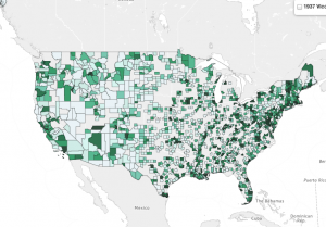 Three maps recently reviewed on TeachersFirst offer three very different “looks” at the world (or U.S.). One, Yale Photogrammar, organizes historic U.S. photographs. In this case, the “map” is actually the portal to see a “world” of the 1930s and 40s. The map itself simply provides clickable “places” of reference for the photographs. It is a visual interface to access visual information. But is that really all? Like most eMaps, this one is zoomable and almost invites you to dive in. You ask whether houses or farms or people were different in Nebraska vs. California? Click to see. What about county to county in Pennsylvania? Click to see. This map is an endless set of windows into lives and times gone by.
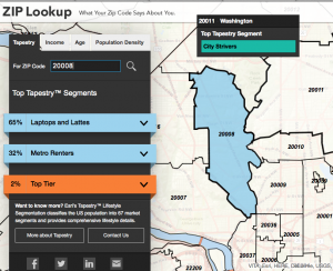 Esri’s Zip Lookup uses a map as the entry point into socio-economic groups, organized by mapped zip codes and described in terms of life style and values. See the make up of the people in a zip code. Who lives here? Comfortable Empty Nesters, Parks and Rec, Laptops and Lattes, Metro Renters? The map is a window into what people care about and spend their money on. We are tempted to ask, “Why here? What is it about this location that attracts this group?” The Zip Lookup map is an invitation to take an almost voyeuristic dive into people’s lives, based on where they live.
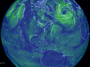 Earth Null School maps the winds on the Earth’s surface. Unlike the weather maps on TV, this globe is in your hands to turn and zoom, watching beautiful swirls that threaten to spin blizzards or floods. This map ignores humans entirely. It does not matter who lives there or what history happened there. The storms on this map don’t care. But we are drawn in to see the power of what may happen here tomorrow or what is closing the airport in Denver today. The Earth really is alive in this map.
If the only maps you have ever seen are eMaps, your view of the world is so much richer. If you teach map skills, share four maps with your students: one the folded paper type, and the other three eMaps listed here. Ask them what each map is GOOD for…what it makes them wonder. If they can answer those questions about each map, they have learned more about map skills than any lesson about keys and tropics. They have discovered the lives within maps.
